Daytona Beach, FL - We're only two weeks into the season and the map is already looking a little crowded.
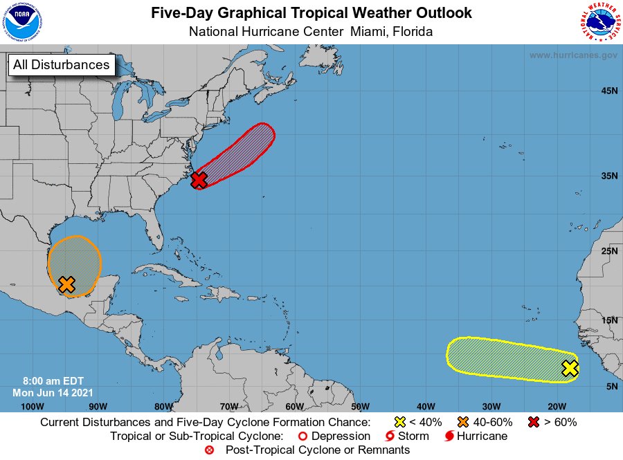
A 5-day forecast from the National Hurricane Center (NHC) released Monday morning (June 14) shows three active disturbances in the Atlantic; one sitting in the western Gulf of Mexico; one near the coasts of North Carolina and Virginia; and one off the African coasts of Sierra Leone and Guinea.
At the moment, forecasters believe the disturbance currently skirting the eastern coast of the United States has the highest chance—70 percent—of developing within the next five days. According to a report on that disturbance, the system's last reported location was around 90 miles southeast of Cape Hatteras as of 8:00 a.m.
The forecast indicates that environmental conditions appear conducive for further development, leading meteorologists to believe that a tropical depression or storm is likely to form sometime on Monday (June 14).
However, whether or not a storm forms, the system's current track has it moving northeastward away from the United States and over colder waters south of Nova Scotia, which will ruin its chances of developing further by midweek.
As for the system currently churning over the Bay of Campeche—the southwest part of the Gulf of Mexico where it is currently located—forecasters say gradual development is possible during the next couple of days while it continues to meander near the coast of Mexico. Development is expected, however, when the system treks northward into the central Gulf of Mexico.
Regardless of its development, forecasters expect the system to bring heavy rain to portions of Central America and southern Mexico during the next several days.
Also on the NHC's radar is a strong tropical wave that's currently making its way west from the western shores of Africa as it produces disorganized shower and thunderstorm activity. Forecasters believe some development is possible over the next few days, but a combination of dry air aloft and strong upper-level winds limit any chance of formation while the wave is over the central tropical Atlantic Ocean later this week.


