

Daytona Beach, FL - If Florida could use anything right now, it would probably be a sprinkle or two of rain. Especially with over 60 wildfires currently active in the state.
Thankfully, most of those fires are already contained. But dry conditions unfortunately make it easier for fires to start, especially when the relative humiditiy is low. Recent reports from the National Weather Service (NWS) in Melbourne say relative humidity levels will fall Thursday afternoon (May 27) before picking up again throughout Friday (May 28) and the upcoming weekend.
That same forecast says isolated showers and storms could blow through the area on Friday, bringing with it some reprieve from dry conditions. However, one possibility to watch out for is the increased chances of lightning storms. According to the NWS, increasing moisture ahead of a weak surface trough will increase those chances into the weekend, especially on Sunday (May 30).
As of Thursday morning, 66 wildfires were reported to be active throughout the State of Florida, with five reported in Volusia County—but most of those fires, 51 to be exact, including those in Volusia, are said to be 100 percent contained. Most of the fires in Volusia lay west of I-95 and north and south of US-92/International Speedway Boulevard. The only fire east of I-95 is the North Brooks fire in the Oak Hill area; which has been contained to 2.5 acres.
Active fires also cover around 5,468 acres of land throughout the state. The biggest active fire in the state right now is the Tree Frog Fire in Indian River County, which currently covers 1,150 acres. That fire is also contained.
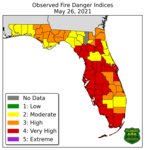
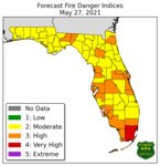
An online map created by the Florida Division of Emergency Management (FDEM) indicates that some parts of South Florida are also dealing with drought, with some areas labeled "abnormally dry" while others are said to be experiencing moderate drought conditions.


